Why Build Cities on Hills?
One of the most surprising things about ancient Israel is that people built their cities on hills, not on level ground in the valleys. In addition, they tried to find the highest hill possible! Why would anyone want to build a city on a hill? Imagine carting your “groceries” or a water jug on your head up several hundred steps every day! You certainly wouldn’t need to go to the gym five times a week–just fetching some water would be a major workout. So why did they build their cities on hills?

This camel shaped hill used to be the town of Gamla located northeast of the Sea of Galilee. Can you imagine living on this steep hill? How would you make the floor of your house level? And going to work in the fields or getting fresh water for drinking and washing meant climbing that hill twice a day. Yet ancient Israelites chose to build their city on this hill and not in the valley. Why? What were they thinking? Life was already tough, why make it tougher?
There were several factors that went into determining where people lived in ancient times. These factors centered around providing the basics of life such as food and water, as well as defending one’s city in the time of war. We have come up with five “W’s” to help remember these key factors:
- War–In ancient times, the issue of keeping your family alive in the time of war was of critical importance. It was the key factor in why cities were built on hills. The best place to defend a city was on top of a high hill which had steep slopes. But sieges were also a problem, so you had to have an ongoing source of water and the ability to store food inside your city walls.
- Walls–Ancient people built on hills, not in the valley, because they could defend themselves better on high ground. On top of the hills they added high and large stone walls to make it even harder for their enemies to get into the city to kill or capture them or their families.
- Water–They built on hills which had water at the base of the hill–water which they could defend and access, but which their enemies could not get to. If your city was being sieged for a long time by a large army you need a source of fresh water.
- Wheat–They also built on hills near valleys where they could grow wheat and other crops so they would have food for daily living, as well as food to store in the time of war.
- Wheels–Lastly, they built on hills next to valleys where their chariots(with their wheels) could manuever and give them military superiority. The Israelites didn’t have chariots for a long time, and as a result they lived in the mountains of Israel, (chariots don’t work well in mountains), while the Canaanites and Philistines who had chariots (wheels) lived in the valleys–they could maneuver their chariots in the flat valleys, which gave them military superiority over the Israelites.
War
War is the key factor because this is the main reason why people in ancient times built on hills. A high hill with steep slopes and a defendable water source near a valley where you could grow crops made it difficult for enemy armies to conquer your city. All the major cities in ancient Israel (Hazor, Megiddo, Samaria, Gezer, Lachish, and Jerusalem) had these characteristics.
The city of Hazor north of the Sea of Galilee is described in Joshua 11:10 as “the head of all these kingdoms.” Why did Hazor become head of all the other city/states (i.e., “kingdoms”) in the north of Israel in Joshua’s time? What made Hazor so prominent? In part it was because Hazor was on a major trade route between Mesopotamia (Assyria and Babylon) in the north, and the Nile Delta (Egypt) in the south. It was also built on a hill with steep slopes on all sides, and there was water at the base of the hill that could be accessed by those inside the city walls and denied to the enemy outside the city walls. That meant the enemy had to cart their water from somewhere else–not an easy task if you’re having to provide water for a large siege army. Those factors made Hazor defensible. Lastly, Hazor was in a valley where crops could be grown to support a large population, and where chariots could be used to defeat any enemy coming against the city. All these factors combined to make Hazor the dominant city in northern Israel.

This aerial view of tel of Hazor doesn’t give you as much of a perspective of the height of the hill or the steepness of the slopes as I would like. However, it does show that the city was located in a valley where crops could be grown and chariots could maneuver. The hill with the sparse trees on it was the citadel or upper city, and was where the king and government officials lived. Note that it is higher than the lower city which is the brown area to the left of the upper city. Even the lower city was on a hill with a steep, sloping side. On top of these hills there would have been a thick stone wall which may have risen an additional 20-30 feet into the air. (Picture source: www.BiblePlaces.com).
Most soldiers know in a battle it’s best to be holding the high ground. This was especially true in ancient warfare. So long ago when people looked for a site for their home or for their city, they looked for a high hill with sharply sloping sides. They would then build a wall around the top of the hill, and build their homes within that wall. That’s why Lachish, Beth Shean, Masada, Machaerus and Jericho were built where they were. Enemy armies couldn’t scale the sides of the hills—at least not easily, and by building a wall around the top of the hill, it made their city even more impregnable.

This picture of Lachish showing the area of the city gate (where the stone retaining walls are) gives some sense of the height and steepness of the slope of the “tel” on top of which the city and the walls were built. (A “tel” is a hill on which ancient cities were built, and which now contains layers of ancient civilizations, one civilization built on top of another as each civilization was destroyed through war, earthquake, or simply the ravages of time). King Sennacherib of Assyria was able to conquer Lachish only by building a ramp up to the city wall. (Picture Source: Rick Moe).

Beth Shean is located just south of the Sea of Galilee and is where King Saul’s body was hung on the city walls after he died. In King Saul’s day the city walls would have been on top of the tel in the background. This tel is very high, which made the city impregnable. In fact, the Israelites did not conquer Beth Shean in the times of Joshua or any of the Judges. It was not until the era of King David and King Solomon that Israel finally conquered and controlled Beth Shean. Why? The high hill, the steep slopes of the hill, and the city wall on top of the hill (the city wall is now gone), made it virtually impossible to conquer. The ruins in the foreground are from the Roman era (after the time of Christ).
(Picture Source: Rick Moe).
Beth Shean is located just south of the Sea of Galilee and is where King Saul’s body was hung on the city walls after he died. In King Saul’s day the city walls would have been on top of the tel in the background. This tel is very high, which made the city impregnable. In fact, the Israelites did not conquer Beth Shean in the times of Joshua or any of the Judges. It was not until the era of King David and King Solomon that Israel finally conquered and controlled Beth Shean. Why? The high hill, the steep slopes of the hill, and the city wall on top of the hill (the city wall is now gone), made it virtually impossible to conquer. The ruins in the foreground are from the Roman era (after the time of Christ). (Picture Source: Rick Moe).

Note the height of Masada above, and the steepness of the slopes. This is why it took the mighty Roman army two years to conquer Masada in the first century A.D., (against only 1,000 Jewish defenders). The Romans couldn’t get to the top of Masada to fight the defenders, so they used Jewish slaves to build a ramp up to the top. When the Romans finally broke through the wall, they found all the Jewish defenders had chosen to commit suicide rather than become slaves. (Picture Source: Rick Moe).

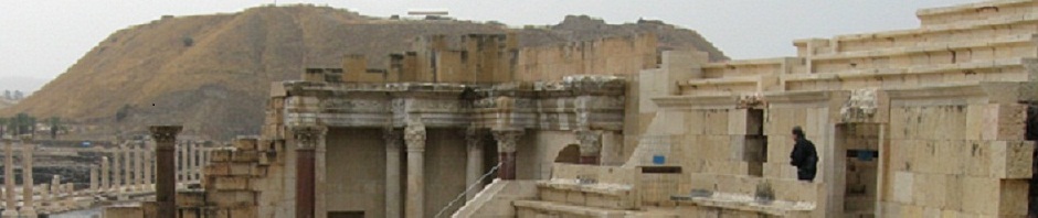
Machaerus is the palace fortress where Herod Antipas most likely imprisoned John the Baptist, and later beheaded him. It is a volcano shaped hill with a flat area on top on which a palatial fortress was built. Jewish leaders, and later the Herod family, selected this hill because of its height and the steep slopes which made it easily defended.
(Picture Source: Rick Moe).

Another view of Gamla showing the valley in which it is located. The valley leads down to the Sea of Galilee which can be seen from here on a clear day.
(Picture Source: Rick Moe).

This picture of Gamla shows the pinnacle of the hill and some of the ruins of the city. The Roman army in 70 A.D. had a hard time conquering this city because the steep slopes and city wall made it difficult for the Roman troops to get into the city to fight the people of Gamla. When they did break through the city wall, the people of Gamla committed suicide by running off the cliff at the back of the hill. Like the people of Masada, they knew the horrors of becoming slaves to the Romans, and choose death over slavery. The flat gray area at the bottom left of the picture is the synagogue. The ruins of the Gamla synagogue are from the first century A.D., and it is very likely that Jesus taught in this synagogue as Gamla is not far from Capernaum.
(Picture source: Rick Moe).
Walls
Walls come into play in the story of the conquest of Jericho by the Israelites. Joshua didn’t have the technology to scale the walls of Jericho or knock them down. Later in history armies learned to build earthen ramps up to the city walls and use battering rams to knock down the walls. This is what the Romans did at Masada, and the Assyrians at Lachish. However, in Joshua’s day, they either didn’t know how to do this, or the process simply hadn’t been invented. So God stepped in and did for the Israelites what they couldn’t do—He knocked down the walls of Jericho so the Israelites could get into the town and conquer the city.

Picture of ancient Jericho showing the excavations by Sellin and Watzinger (they excavated in 1907-1909, 1911). It shows Jericho’s revetment wall of uncut stones (bottom right next to the man), a thick mud brick wall on top of the revetment wall, and some of the ruins of the buildings inside the city (on the left).
(Source of the picture above and drawing below: Dr. Bryant Wood of the Associates for Biblical Research, http://www.biblearchaeology.org/post/2008/05/01/Did-the-Israelites-Conquer-Jericho-A-New-Look-at-the-Archaeological-Evidence.aspx#Article)

Drawing of the walls of ancient Jericho showing (on the right) the revetment wall of larger uncut stones on the bottom with the mud brick wall on top of it. It was the mud brick walls which fell down (as shown in the drawing). Further up the tel was a second mud brick wall protecting the inner city where the king and other city officials lived. Portions of this wall also collapsed. Rahab’s house would have been in the poorer part of town, and the Bible implies her house was located on the outer wall on a section where the mud brick wall did
not collapse.

On top of the incredibly high and steep slopes of Masada, Herod the Great still built a wall all around the top. As can be seen above, the wall was a double wall, called a “casement wall.” In between the two parallel walls they would build walls that went between the two main walls. This strengthened the double walls and also made little rooms that people could live in or use for storage. Even though Masada is incredibly high, Herod the Great knew a wall was still important. One of the reasons the Romans needed to build a ramp (see the next picture) was because they needed to bring up their battering rams so they could break through Herod’s wall and get onto the area on top of Masada. Without a wall, it would have been easier for the Romans to get onto the top of Masada.
(Picture source: Rick Moe).

The Romans built this ramp up to the top of Masada so they could bring up their battering rams to knock down the casement wall which Herod the Great had built. Notice how steep the ramp is and how much labor must have gone into building the ramp. It was the height and steepness of the slopes on Masada which made it such an impregnable fortress in ancient times.
(Picture source: Rick Moe).
Water
In ancient times you also needed to have a source of water which you could guard and keep from your enemies. That’s why at Beersheba they dug a deep tunnel within the city walls so they could get down to the spring at the base of the hill. (They did the same at Megiddo, Gibeon and Jerusalem).

This is Beersheba’s water shaft. Barely visible is a man with a hard hat on at the bottom. This water shaft, like the one at Megiddo and Gibeon, is inside the city walls so the citizens of the city could have access to water during a siege, but the enemy would be denied this valuable resource.
(Picture Source: Rick Moe).

The water shaft at Gibeon. Note the size of the people in the top right of the photo. The citizens of Gibeon went to a lot of work to dig this shaft from the top of the tel, through bedrock. The amount of work shows how important obtaining and protecting one’s water supply was for a city.
(Photo courtesy ofwww.BiblePlaces.com).

One of the most famous water systems in Israel is Megiddo’s in the Jezreel Valley (the northern part of Israel). This pictures shows the shaft they dug from the top of the tel down to a tunnel (next picture) that ran to the side of the tel where the spring was located. (Picture source: Rick Moe).

Notice that the people of Megiddo cut through solid rock for a long ways to get from the bottom of the water shaft to the spring at the side of the tel.
(Picture source: Rick Moe).
The reason why ancient Jerusalem is located on the hill where it is and not on the higher hills of the Mt. of Olives or the Western Hill is that the Gihon Spring is at the foot of ancient Jerusalem. In King David’s and King Solomon’s time they built towers over the Gihon Spring in order to protect the water (see drawing below). The remains of these towers are visible today (see picture below the drawing). Later in history King Hezekiah dug a tunnel to divert the water to the Siloam Pool. That way all the water would be within the city walls during the siege of the Assyrian army. It also kept the Assyrians from having easy access to water as they had to travel elsewhere to get the water they needed. Once again, the location of a spring determined the location of an ancient city.

This drawing shows what Jerusalem might have looked like in the days of King David and King Solomon based on our current archaeological knowledge. Notice the four towers on the right which guarded the Gihon Spring. Several hundred years later King Hezekiah diverted the waters of the Gihon Spring by digging a tunnel under the city (through solid rock) so the water from the Gihon Spring would flow to the Pool of Siloam.
(Picture source: Rick Moe).

The massive stones at the bottom of this picture are the remains of one of the towers that guarded the Gihon Spring–the source of water for ancient Jerusalem.
(Picture source: Rick Moe).

The waters of the Gihon Spring can be seen bubbling up from underground in this picture. (Picture source: Rick Moe).

King Hezekiah dug this tunnel through solid rock under the city of Jerusalem in order to have a continuous source of water during the siege of King Sennacherib of Assyria.
(Picture source: www.BiblePlaces.com).
Wheat
In the time of war you had to have “wheat” (which stands for all types of food) which you could grow, harvest, collect and store inside the city walls before the enemy got to your city and laid siege to it. Of course, wheat (food) was needed all the time, so major cities were located on defensible hills near valleys where wheat and other crops could be grown.

Earlier we showed you the major city of Hazor located in the Hula Valley north of the Sea of Galilee. The picture above is of Rick Moe standing on the tel of Megiddo with the Jezreel Valley in the background. Once again, the location of this ancient city was near a valley where food and wheat could be easily grown to feed the inhabitants of the city.
(Picture source: Rick Moe).

The importance of the ability to store food is seen in this picture (and the one below) from the archaeological digs at Jericho. The Bible says Joshua and the Israelites did not take anything from Jericho (except what Achan disobediently took). This included the stored grain, which would have been one of the first things a conquering army would have looted. After all, a conquering army needs to eat too, so harvested grain would have been a highly prized commodity for a conquering army. The fact that the grain in these large vessels was burnt along with the rest of the city is very unusual, and confirms what the Bible says happened when Israel conquered Jericho.
(Picture source for the pictures above and below: http://www.biblearchaeology.org/post/2008/05/Did-the-Israelites-Conquer-Jericho-A-New-Look-at-the-Archaeological-Evidence.aspx#Article).

Notice the black, charred grain in this large storage jar from Jericho.
Wheels
“Wheels” stand for chariots which allowed technologically advanced nations to conquer less technologically advanced nations who didn’t know how to use metal or shape it into useful military machines (like swords, armor, or chariots). In the Old Testament before King David’s time, Israel was the less technologically advanced nation, and the more advanced nations were the Egyptians, Philistines, and Canaanites.

Drawing of an ancient Egyptian chariot.
(Picture source: http://newmedia-eng.haifa.ac.il/?p=3309. Their website says “University of Haifa Copyright © 2011 All Rights Reserved,” but no terms of usage could be found. This picture was first found on several other websites).

One of six chariots found in King Tutankhamun’s tomb.
(Picture source: http://www.touregypt.net/marketplace/tomb-antechamber.htm. No policy regarding the use of their pictures on other websites or blogs could be found).

Another of King Tutankhamun’s chariots.
(Picture source: http://news.discovery.com/history/zooms/king-tut-chariot.html. The Discovery Channel website credits the photo to the Egyptian Museum, and their website states: Copyright © 2011 Discovery Communications, LLC. However, no policy regarding the use of their pictures on other websites or blogs could be found).
Judges 1:19 states, “The Lord was with the men of Judah. They took possession of the hill country, but they were unable to drive the people from the plains, because they had iron chariots.” Chariots work well on flat ground like what you find on “the plains.” But they don’t work well on hills and ravines like what you find in “the hill country.” That is why Judah could take possession of the hill country, but not the plains. The people living on the plains had chariots. They also had the ability to use iron, which the Israelites did not–at least not through the reign of King Saul. The fact that the Philistines and Canaanites had iron technology and chariots is the reason why the Israelites were confined to the hill country and could not conquer the plains.
First Samuel 13:19-22 states that during the reign of King Saul, “Not a blacksmith could be found in the whole land of Israel, because the Philistines had said, ‘Otherwise the Hebrews will make swords or spears!’ So all Israel went down to the Philistines to have their plowshares, mattocks, axes and sickles sharpened…. So on the day of the battle not a soldier with Saul and Jonathan had a sword or spear in his hand; only Saul and his son Jonathan had them.”
This explains why David did not wear armor when he went out to fight Goliath. He tried on King Saul’s armor, but it was too big for him. Saul and Jonathan were the only two men in Israel who had armor, so when King Saul’s armor was too big for David they couldn’t go to the local army surplus store and get a smaller size. David had to face Goliath without armor. However, God used what David had–a sling and five smooth stones–and won a great victory and brought Himself much glory through David’s faith and obedience.
At the end of King Saul’s life, the Israelites went to the Valley of Jezreel to fight the Philistines who controlled Beth Shean (next picture below). Why the Jezreel Valley? Because the Philistine’s chariots worked well in the Jezreel Valley, and that valley cuts off northern Israel (Galilee) from central and southern Israel (Ephraim and Judah). Israel and King Saul knew the Philistines had chariots and so they didn’t want to fight in the valley, so they camped on Mount Gilboa tried to fight the Philistines on it slopes where the chariots could not go. Even so, the Philistines were militarily superior, and King Saul and his army were decimated on Mount Gilboa.
First Samuel 31:8-10 says, “The next day, when the Philistines came to strip the dead, they found Saul and his three sons fallen on Mount Gilboa. They cut off his head and stripped off his armor, and they sent messengers throughout the land of the Philistines to proclaim the news in the temple of their idols and among their people. They put his armor in the temple of the Ashtoreths and fastened his body to the wall of Beth Shean.” Beth Shean is located where the Jezreel Valley and the Jordan Valley meet.

This picture shows one of two main roads at Beth Shean from the Roman era (after the time of Christ). The hill where the Philistines hung King Saul’s body is the hill in the background.
(Picture source: Rick Moe).
Not until King David did Israel get the technology of working with iron. Interestingly, when David was running from King Saul, one of the places he fled to (and where he lived for several years) was the territory of the Philistines. Israel didn’t have iron technology before David lived with the Philistines, but they did afterward. Could it be that David and his men learned how to work with iron while they lived among the Philistines, then brought that technology back to Israel when David became king? It sure is mighty coincidental.
The ability to use iron is one of the main reasons why King David and King Solomon were able to build their vast kingdoms. Instead of being behind the times, they were now the ones with the technology and knew how to use it against their enemies. As a result, they conquered the world of their day. Isn’t it interesting how God uses things like iron technology to further His plans? As Christians we need to learn to use the technology and media of our day to further God’s kingdom, rather than be behind the times and let the enemy of our souls use it to his advantage.
Acknowledgement
I am grateful to my friend Allan Rabinowitz who came up with these 5 ”W’s.” Allan was my Israeli tour guide when I led tours to Israel and Jordan in 2007 and 2011. He used the 5 “W’s” to help us understand the sites we visited. I highly recommend Allan if you need a tour guide in Israel. He was born and raised in the United States, so he speaks “American English,” and is easy to understand for tourists coming from the U.S.

Allan Rabinowitz leading our 2010 tour at the City of David overlook. In the background are the Temple Mount (wall on the top left of the picture), the Mount of Olives (across the top of the picture) and the Kidron Valley (lower right).
(Picture source: Charlene Heaston).
Picture Copyrights: All pictures taken by Rick Moe are public domain and permission is granted to use them. Pictures who’s copyright information is noted should not be used by other websites or blogs unless permission is obtained from the original website.
